


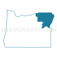
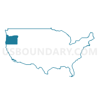
Umatilla, Union, Baker & Wallowa Counties PUMA, Oregon
About
Outline

Summary
| Unique Area Identifier | 193812 |
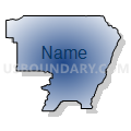
| Name | Umatilla, Union, Baker & Wallowa Counties PUMA |
| State | Oregon |
| Area (square miles) | 11,509.98 |
| Land Area (square miles) | 11,466.66 |
| Water Area (square miles) | 43.32 |
| % of Land Area | 99.62 |
| % of Water Area | 0.38 |
| Latitude of the Internal Point | 45.30189510 |
| Longtitude of the Internal Point | -117.90274260 |
Maps
Graphs
Select a template below for downloading or customizing gragh for Umatilla, Union, Baker & Wallowa Counties PUMA, Oregon


Neighbors
Neighoring Public Use Microdata Area (by Name) Neighboring Public Use Microdata Area on the Map
- Ada (North), Payette, Canyon (North), Gem & Washington Counties--Eagle City PUMA, ID
- Central Idaho--Lewiston City & Nez Perce Reservation PUMA, ID
- Klamath, Malheur, Lake & Harney Counties PUMA, OR
- North Central Oregon--The Dalles City PUMA, OR
- Walla Walla, Benton (Outer) & Franklin (Outer) Counties PUMA, WA
- Whitman, Asotin, Adams, Lincoln, Columbia & Garfield Counties PUMA, WA
Top 10 Neighboring County (by Population) Neighboring County on the Map
- Benton County, WA (175,177)
- Umatilla County, OR (75,889)
- Walla Walla County, WA (58,781)
- Nez Perce County, ID (39,265)
- Malheur County, OR (31,313)
- Union County, OR (25,748)
- Asotin County, WA (21,623)
- Idaho County, ID (16,267)
- Baker County, OR (16,134)
- Morrow County, OR (11,173)
Top 10 Neighboring County Subdivision (by Population) Neighboring County Subdivision on the Map
- Walla Walla-College Place CCD, Walla Walla County, WA (48,677)
- Hermiston-Umatilla CCD, Umatilla County, OR (36,477)
- Lewiston CCD, Nez Perce County, ID (34,319)
- Pendleton CCD, Umatilla County, OR (19,339)
- La Grande CCD, Union County, OR (16,846)
- Baker City CCD, Baker County, OR (10,893)
- Milton-Freewater CCD, Umatilla County, OR (10,851)
- Weiser CCD, Washington County, ID (8,543)
- Boardman CCD, Morrow County, OR (7,997)
- Grangeville CCD, Idaho County, ID (6,290)
Top 10 Neighboring Place (by Population) Neighboring Place on the Map
- Hermiston city, OR (16,745)
- Pendleton city, OR (16,612)
- La Grande city, OR (13,082)
- Baker City city, OR (9,828)
- Milton-Freewater city, OR (7,050)
- Umatilla city, OR (6,906)
- Union city, OR (2,121)
- Stanfield city, OR (2,043)
- Enterprise city, OR (1,940)
- Elgin city, OR (1,711)
Top 10 Neighboring Unified School District (by Population) Neighboring Unified School District on the Map
- Kennewick School District, WA (85,577)
- Walla Walla School District, WA (37,579)
- Hermiston School District 8, OR (26,789)
- Pendleton School District 16, OR (22,021)
- La Grande School District 1, OR (16,990)
- Baker School District 5J, OR (13,509)
- College Place School District, WA (12,899)
- Milton-Freewater School District 7, OR (11,750)
- Morrow School District 1, OR (10,541)
- Mountain View School District 244, ID (9,920)
Top 10 Neighboring State Legislative District Lower Chamber (by Population) Neighboring State Legislative District Lower Chamber on the Map
- State House District 16, WA (154,830)
- State House District 9, WA (136,166)
- State House District 58, OR (62,100)
- State House District 59, OR (60,455)
- State House District 57, OR (57,718)
- State House District 60, OR (55,458)
- State House District 7, ID (39,265)
- State House District 8, ID (38,711)
- State House District 9, ID (38,220)
Top 10 Neighboring State Legislative District Upper Chamber (by Population) Neighboring State Legislative District Upper Chamber on the Map
- State Senate District 16, WA (154,830)
- State Senate District 9, WA (136,166)
- State Senate District 29, OR (119,818)
- State Senate District 30, OR (115,913)
- State Senate District 7, ID (39,265)
- State Senate District 8, ID (38,711)
- State Senate District 9, ID (38,220)
Top 10 Neighboring 111th Congressional District (by Population) Neighboring 111th Congressional District on the Map
- Congressional District 1, ID (841,930)
- Congressional District 4, WA (774,409)
- Congressional District 2, OR (769,987)
- Congressional District 5, WA (723,609)
Top 10 Neighboring Census Tract (by Population) Neighboring Census Tract on the Map
- Census Tract 9512, Umatilla County, OR (8,814)
- Census Tract 9209, Walla Walla County, WA (8,508)
- Census Tract 9701, Morrow County, OR (7,997)
- Census Tract 9508, Umatilla County, OR (7,881)
- Census Tract 9502, Umatilla County, OR (7,643)
- Census Tract 9602, Idaho County, ID (6,290)
- Census Tract 9510, Umatilla County, OR (6,259)
- Census Tract 9504, Umatilla County, OR (6,256)
- Census Tract 9506, Umatilla County, OR (6,206)
- Census Tract 9709, Malheur County, OR (5,899)
Top 10 Neighboring 5-Digit ZIP Code Tabulation Area (by Population) Neighboring 5-Digit ZIP Code Tabulation Area on the Map
- 99362, WA (41,056)
- 83501, ID (34,230)
- 99337, WA (29,845)
- 97838, OR (25,346)
- 97801, OR (21,521)
- 97850, OR (16,955)
- 97814, OR (12,382)
- 97862, OR (11,666)
- 83672, ID (8,583)
- 97882, OR (7,760)